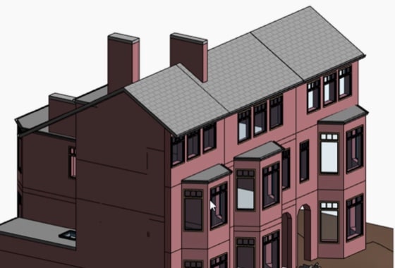
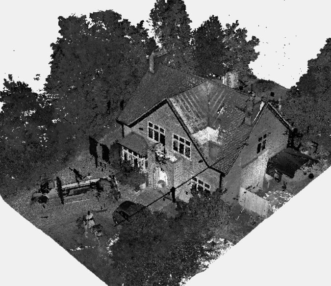
We will survey all accessible floors in the property and provide plans showing all visible walls, windows, doors, spot height levels, ceiling/roof heights, window sill/head heights.
A topographic survey – also known as a topographic survey – is a detailed, accurate representation of the natural and man-made features of an area of land. It maps out the contours, boundaries, levels and physical features of a site, providing essential information for architects, property developers, engineers and construction professionals.
Before any land development, construction or major landscaping can begin, it is crucial to understand the exact shape and characteristics of the terrain. This is where a topographical survey comes in. Such surveys help to streamline the planning process by avoiding costly mistakes.
At XP Surveys, we specialise in providing high-precision topographical surveys using cutting-edge technology to ensure that every feature, from underground utilities to tree lines, is captured with meticulous accuracy.
Considerations Assessed During A Topographical Land Survey Include:
- Natural features and environmental considerations
- Man-made features, both current and historic
- Location of utilities, identified by drainage covers, electricity poles, gas meters, etc. In London in particular, there can be a huge amount going on under the ground, see this helpful article on Thames Water Build-Over Agreements
- The surroundings, e.g. shade from neighbouring properties and the potential light blocking on neighbours, being overlooked or overlooking surrounding buildings, blocking views above certain heights, and surrounding environment considerations
Topographical surveys are 3-dimensional (height being an important measurement, not just gridline position), and will often be related to GPS positioning and/or Ordinance Survey references. CAD software is the widely accepted industry standard that allows accurate 3D mapping to be saved digitally, which can then be outputted in a variety of 3D and 2D views as required.
An extract from a topographical survey is shown on our topographic services page, showing the level of detail and accuracy of measurements.
The Purpose of a Topographical Survey in Land Development
For land developers and architects, a topographical survey is a critical first step in the planning and design phase. Here’s why:
- Risk Mitigation: Identifying potential obstacles or environmental constraints early can prevent costly rework later.
- Legal Compliance: Many planning authorities require a detailed topo survey as part of the planning application process.
- Design Accuracy: A comprehensive understanding of the site’s levels and features ensures designs are feasible and safe.
- Environmental Awareness: Surveys can highlight sensitive natural features or drainage issues that need to be addressed.
In short, a topographic survey gives you the data needed to make informed decisions and helps ensure your project runs smoothly from the outset.
Do I Need A Topographical Survey?
If your project is relatively small – for example, a house extension – it’s unlikely a full topographical survey will be needed. Smaller projects that might require a topographical survey include moving or establishing boundaries.
For larger projects, however, planning authorities will require a topological survey as they will refer to it for considerations such as understanding the visual and environmental impact of the development and how it will connect with existing infrastructure and services.
You can book a Professional Topographical Survey through our instant quote tool.
Who Uses Topo Surveys?
Whilst topo surveys are often requested by architecture firms and property developers, the range of people and organisations that may want a topographical survey conducted is wide.
Homeowners and commercial property owners who want to assess the value of their property or section of land for future alternative development may well need a topo survey to help them evaluate this.
And construction companies who have an in-house design team are another common client of a topographical survey provider such as XP Surveys.
What Does a Topographic Survey Include?
A typical topographical survey includes:
- Natural Features: Trees, watercourses, slopes and vegetation.
- Man-Made Features: Buildings, roads, fences, walls, utilities.
- Boundaries: Property lines and legal boundaries.
- Elevations & Contours: Vertical differences captured through contour lines.
- Underground Utilities: Detected with specialist survey equipment.
- Drainage: Gullies, manholes and flow directions.
This data is presented in a topographic map or CAD drawing, giving professionals a clear, accurate picture of the site.
| Feature Type | Examples | Why It Matters |
| Natural Features | Trees, slopes, streams | Environmental impact and design constraints |
| Man-Made Features | Buildings, roads, walls | Planning and construction alignment |
| Boundaries | Fences, legal property lines | Prevent disputes and ensure compliance |
| Elevation Data | Contours, spot heights | Groundworks and flood risk assessment |
| Utilities | Drainage, pipes, cables | Avoid costly service clashes during works |

Types of Topographic Surveys
There are several types of topographical surveys, each suited to different needs:
- Boundary Surveys: Define legal property lines.
- As-Built Surveys: Confirm the position of built structures.
- Construction Surveys: Guide construction works and monitor progress.
- Hydrographic Surveys: Map underwater terrain and bodies of water.
- Aerial (Drone) Surveys: Quickly capture large areas from above.
The type of survey you need depends on the level of detail required and the nature of the development project.
Important Considerations - Why Choose XP Surveys
- Accuracy – if you’re planning to put down foundations close to a mains water feed or electric cable or sewer, you need to know your measurements are accurate! XP Surveys use technology which is accurate to within + or – 2mm.
- Thoroughness – also known as attention to detail – there’s no point in researching 9 out of 10 important considerations and leaving 1 or 2 major issues out of the report, that would scupper the proposed development in the late stages of the planning application. Companies conducting a topographical survey service need to consider every possible aspect that could constrain or even prevent the proposed development, even if a skilled architect can then design a workaround, they still need to be identified in the first place. For this reason, hiring a specialist firm of topographical survey professionals like XP Surveys is crucial, their experience and level of detail will provide the correct level of service, in contrast with a more general surveying company. A good topo survey professional will be collaborative and consult with a variety of other specialists where required, such as tree preservation specialists, bat survey specialists, etc.
- Service Levels – construction projects have deadlines and involve a complex network of different professions and organisations, including architects, council planning departments, construction companies, and clients. Good quality service aspects like turning up for the survey at the agreed date and time are an important consideration when selecting a firm to conduct a topo survey.
Standard Pricing and Bespoke Packages
While our measured survey pricing guide gives helpful and transparent information on the typical costs of topo surveys, we do regard every survey request as a bespoke requirement. Use our Quote Request tool or contact us for a fast response.
If a site warrants a particularly detailed examination of various aspects, maybe due to its conservation area status or historic significance, or even due to the ambitious nature of the planned development, then a tailored survey package will be quoted on each occasion, suited to your requirements.
The Topographical Survey Process: How Surveys are Conducted
At XP Surveys, we follow a streamlined process to ensure speed and accuracy:
- Initial Enquiry & Quote: Provide project details and receive an instant quote.
- Site Visit & Equipment Setup: Our surveyors visit the site with advanced survey equipment such as total stations and GPS.
- Data Collection: Using laser scanning and other tools, we capture precise measurements.
- Data Processing: Back in the office, the information is processed into detailed CAD or Revit drawings.
- Delivery: Drawings are delivered in your chosen format — 2D, 3D, PDF or AutoCAD.
Our four-step process ensures every project benefits from pinpoint accuracy and rapid turnaround times.
What Equipment Is Used in a Topographic Survey?
Modern topographical surveys rely on state-of-the-art tools, including:
- Total Stations: For precise angular and distance measurements.
- GPS Receivers: Capture geospatial coordinates linked to Ordnance Survey grids.
- 3D Laser Scanners: Create highly detailed point clouds.
- Drones (UAVs): For efficient surveying of large or hard-to-access areas.
- CAD Software: For processing and presenting the data.
The choice of survey equipment directly affects the level of detail and accuracy — something XP Surveys prioritises on every job.
How Much Does a Topographic Survey Cost?
The cost of a topographical survey varies based on:
- Area of land (size and complexity)
- Level of detail required
- Location and accessibility
Typical costs can range from £399 to £2,500+. At XP Surveys, you can get an instant quote online, giving you full cost transparency from the outset.
Beware of low-cost providers — inaccurate data could lead to planning rejections, costly redesigns or legal issues later.
When Do You Need a Topographical Survey?
Common scenarios requiring a topo survey include:
- Before architectural design or extensions
- Resolving boundary disputes
- Conducting a flood risk assessment
- Submitting a planning application
- Undertaking major landscaping or earthworks
If your project involves changes to the land or built environment, a topographical survey is a smart investment.
How Topographical Surveys Benefit Architects, Engineers and Planners
An accurate topographic survey empowers:
- Architects: To design structures that work with the land, not against it.
- Engineers: To plan infrastructure with confidence.
- Planners: To satisfy environmental and legal requirements.
At XP Surveys, our CAD-ready surveys integrate seamlessly into your design workflow, saving time and reducing errors.
Interpreting a Topographic Map: What to Look For

A topographic map uses lines and symbols to represent terrain:
- Contour Lines: Show elevation changes. The closer the lines, the steeper the slope.
- Spot Heights: Indicate exact elevation at specific points.
- Symbols: Represent features like trees, walls, utilities.
Understanding these basics is essential for anyone working with land or planning permissions.
Quick Reference:
- Close contours = Steep terrain
- Widely spaced contours = Gentle slopes
- Dashed lines = Proposed features
Topographical Surveys and Environmental Considerations
Accurate surveys also support environmental planning by:
- Identifying flood risks
- Highlighting protected vegetation
- Mapping watercourses and drainage
For sustainable development, a topographical survey is essential.
Choosing the Right Surveyor for Your Topographical Land Survey
When selecting a land surveyor, look for:
- Experience in similar projects.
- Advanced technology (e.g. laser scanning, drones).
- Accurate, CAD-ready outputs.
- Positive client testimonials.
- Fast turnaround times.
At XP Surveys, our clients — including architects, developers and engineers — choose us for our unmatched accuracy, speed and dedicated support.
Explore our Topographical Survey Services to see how we can support your next project.
Why a Topographical Survey is a Smart Investment
A topographical survey is far more than just a set of drawings — it's the foundation of successful land development. By choosing an experienced provider like XP Surveys, you can be confident that your project will be built on accurate data, avoiding delays, cost overruns and compliance issues.
Get your instant topographical survey quote today or speak to an expert and let XP Surveys help bring your vision to life with precision and confidence.


