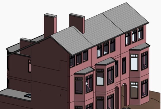
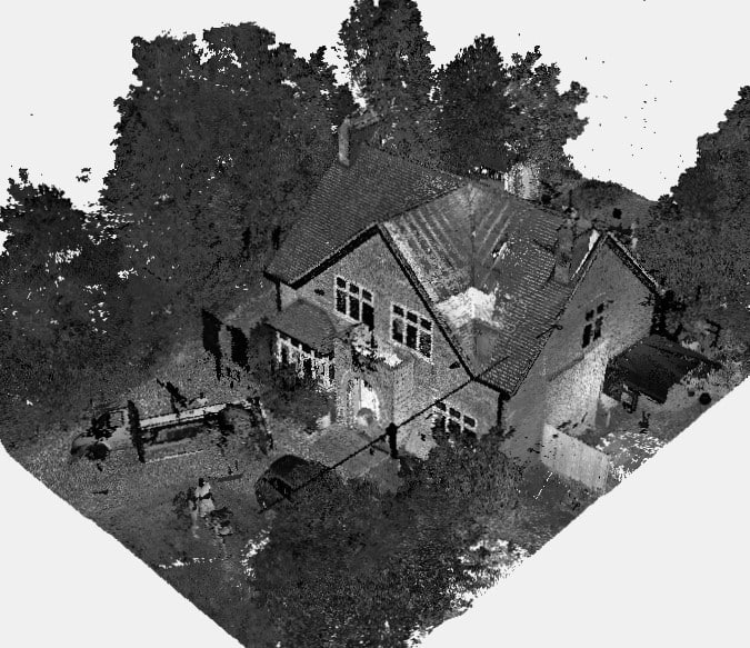
We will survey all accessible floors in the property and provide plans showing all visible walls, windows, doors, spot height levels, ceiling/roof heights, window sill/head heights.
In the world of architecture planning and property development, precision and accuracy at the survey stage are paramount. Before any construction plans or renovation concepts can take shape, architects and developers require detailed information about the existing structures and surroundings. So too will the local planning department need to see ‘as-is’ and proposed development drawings to understand the physical and visual impact of the redevelopment.
This crucial, initial step is facilitated by measured surveys, which provide the essential data for architects and developers to make informed decisions, and generate new plans.
XP Surveys have a long history of working closely with architects to provide their measured survey requirements, and our surveyors all come from strong architectural backgrounds. In this blog post, we’ll delve into the significance of measured surveys and look at what architects and property developers need from them.
Understanding Measured Surveys
A measured survey is a comprehensive assessment of a property or site, capturing accurate measurements and detailed information about its physical features. These surveys serve as the foundation for all subsequent design, planning, and construction calculations, offering architects and developers invaluable insights into the existing parameters and potential of a site.
If architect drawings are the communication tool of the construction world, measured survey data forms the letters and words.
Key Requirements For Architects And Property Developers
Precision and Accuracy
Architects rely on measured surveys to obtain precise measurements of existing structures, land contours, and boundaries. Accurate data ensures that subsequent design and plans align seamlessly with the site’s characteristics, minimising errors, and optimising space utilisation.
Measurement errors at the initial stage can have severe consequences further down the line, legally, financially, and reputationally.
Measured surveys that focus on land features, rather than building details, are often referred to as topographical or ‘topo’ surveys.
Rapid Turnaround
As not much can be started before the architect has possession of the required measurement data, it’s crucial that the surveyor can respond promptly, undertaking the measured survey and delivering the resulting measured drawing data on time. Any delays or uncertainty can affect the rest of the project and its ultimate completion.

Detailed 3D Models
Incorporating advanced technologies such as laser scanning and photogrammetry, modern measured surveys produce highly detailed 3D models of properties and landscapes. Architects and developers benefit from these intricate digital models, which provide a comprehensive understanding of spatial relationships and facilitate the visualisation of design concepts.
Architect’s models up until the last century involved hundreds of hours of manual work and were only used for larger scale, public buildings; projects that usually spanned a few years. Today’s digital scanning and formats such as Revit, Archi-cad, and BIM (Building Information Modelling) standards and software allow small to large-scale projects to be modelled at speed and within budget.
As-Built Documentation
Measured surveys generate as-built documentation, which records the current state of a property or site. Architects and developers use this documentation as a reference throughout the design and construction phases, ensuring that the final outcome adheres to the original specifications and regulatory requirements.
On completion of the building, a measured survey can also be done to check the accuracy of work and a refreshed ‘as-built’ record for hand-over to the building occupier or new owner.
Compliance With Regulations
Adherence to regulatory standards and building codes is paramount in architecture and property development. Measured surveys assist architects and developers in assessing compliance with zoning regulations, setback requirements, and other legal constraints, thereby mitigating the risk of costly delays or disputes.
Streamlined Workflows
Efficiency is crucial in the fast-paced world of architecture and development. Measured surveys facilitate streamlined workflows by providing architects and developers with comprehensive data upfront, enabling them to make informed decisions and progress swiftly through the planning and design stages.
Standardised measurement units and professional standards have long enabled architects, contractors and other parties to work together on projects. Over the past decade or so, BIM standards have developed to better enable complete building information to be shared and updated in real-time over the course of a project.

Collaboration And Communication
Effective collaboration among project stakeholders is essential for success. Measured surveys facilitate clear communication between architects, developers, engineers, and contractors, ensuring that everyone is aligned with the project’s goals and requirements from the outset.
In conclusion, measured surveys play a vital role in the work of architects and property developers, providing them with the essential data and insights needed to execute successful projects.
Building projects can all too easily run over time and budget, so obtaining the level of detail accurately, without delay, can help get things off to a good start.
From precise measurements to detailed 3D models, these surveys equip professionals with the information necessary to navigate the complexities of design, planning, and construction. By prioritising accuracy, efficiency, and collaboration, architects and developers can leverage measured surveys to achieve their objectives and deliver outstanding results.
For architects and property developers seeking reliable and comprehensive measured survey solutions, XP offers expertise, technology, and professionalism to meet your specific needs.
Contact us today to learn more about how we can support your projects with tailored measured surveying services.


