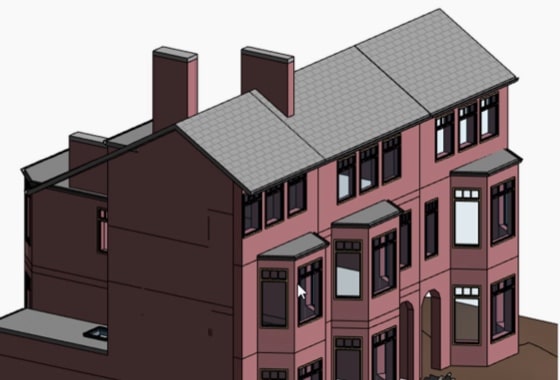
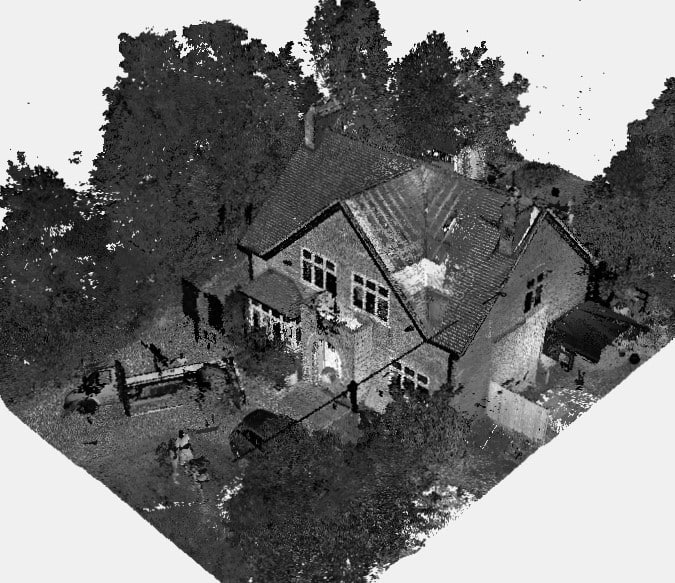
We will survey all accessible floors in the property and provide plans showing all visible walls, windows, doors, spot height levels, ceiling/roof heights, window sill/head heights.
When planning a construction, renovation or development project, accurate survey data is essential. From architects and engineers to homeowners and property developers, everyone relies on precise measurements to bring their visions to life. Yet, there is often confusion around two key types of surveys: the topographical survey and the measured survey. So, what’s the difference, and how do you know which one you need?
In this guide, we’ll clarify the distinctions between these two essential land and building survey types, helping you make an informed decision for your project.
What Is a Topographical Survey?
A topographical survey (also referred to as a topographic survey or topo survey) is a detailed and accurate representation of the natural and man-made features of a piece of land. It maps out:
- Contours and ground levels
- Man-made features such as roads, fences, and utilities
- Natural features including trees, watercourses, and vegetation
- Elevations and slopes
A topographical survey is typically used for land development, infrastructure planning and environmental projects, where understanding the land’s shape, elevation and constraints is critical.
Key Features of a Topographical Survey
- Methods Used: Advanced techniques such as drone surveys, GPS and total stations capture precise site data.
- Level of Detail: The level of detail is tailored to the project specification — capturing everything from minor landscape features to complex site topography.
- When You Need One: Ideal for projects involving land boundaries, drainage planning, site design and infrastructure works.
What Is a Measured Survey?
A measured survey (or measured building survey) focuses on the built environment rather than the landscape. It captures the precise dimensions and layout of buildings, both internally and externally.
Measured surveys typically include:
- Floor plans
- Elevations
- Sections
- Structural details

These surveys are essential for refurbishment projects, architectural design, planning applications and property alterations.
Key Features of a Measured Survey
- Technologies Used: Our surveyors use laser scanning, 3D point cloud capture and CAD software to produce highly detailed outputs.
- Building Types Covered: From small residential homes to large commercial properties and heritage buildings requiring preservation-sensitive documentation.
- Output: CAD-ready drawings, 3D models and detailed reports.
XP Surveys offers fast, precise measured building surveys that support effective decision-making and design accuracy.
Topographical Surveys vs Measured Surveys: Key Differences Explained
| Feature | Topographical Survey | Measured Survey |
| Scope | Land, terrain and external features | Buildings: internal & external detail |
| Outputs | Contour maps, site plans, elevations | Floor plans, elevations, sections |
| Methods | Drone, GPS, total stations | Laser scanning, CAD, 3D models |
| Primary Use | Planning, infrastructure, land development | Design, refurbishment, architectural plans |
| Cost Implications | Varies based on site area and complexity | Based on building size, detail required |
Both survey types serve distinct purposes. A topographical survey is land-focused, while a measured survey is building-focused. However, in complex projects — such as a new-build on a sloped site — you might need both surveys for a complete picture.
How to Choose the Right Survey for Your Project
To choose the right survey, consider:
- Project Type: Land development vs. building works.
- Level of Detail Required: Does your architect need full interior elevations or just site contours?
- Accuracy Needs: Heritage sites and complex builds may require higher precision.
- Budget: The scope and complexity influence survey cost.
In some cases — such as large-scale redevelopments or planning applications — you may benefit from combining both topographical and measured surveys.
How Much Does a Survey Cost?
While exact prices vary, several factors affect the survey cost:
- Site or building size
- Level of detail and specification
- Accessibility
- Deliverables required (2D CAD, 3D models, etc.)
At XP Surveys, you can receive an instant quote for your project by using our online tool. Our team of expert surveyors ensures each survey is accurate, timely and cost-effective.
Common Questions About Land and Building Surveys
Here are answers to some frequently asked questions about land and building surveys:
- Do I need a survey for planning permission?
In most cases, yes. Accurate topographical surveys or building surveys help ensure that planning drawings meet local authority requirements. - How long does a survey take?
Typically, site work can be completed within a day or two, with drawings delivered within five working days — depending on project size. - Can I use old survey data?
We advise caution. Outdated surveys may not reflect current site conditions, leading to design or construction errors.
Working with Surveyors: What to Expect
When engaging with professional topographical surveyors or measured survey teams like XP Surveys, here’s what you can expect:
- Clear Briefing: Share your project scope, specification and timescales. If you’re working with an architect, involve them early.
- Deliverables: Expect CAD-ready drawings, 3D models and clear documentation tailored to your project needs.
- Qualified Professionals: Accuracy matters. Choosing experienced surveyors ensures your project has a solid foundation of reliable data.
Choosing the Right Survey Partner
Both topographical surveys and measured surveys play a vital role in the success of building and development projects. Choosing the right type — and the right survey partner — can save you time, money and frustration.
At XP Surveys, we combine pinpoint accuracy, state-of-the-art technology and fast turnaround times to help property professionals and homeowners bring their visions to life.
For expert guidance or an instant quote, speak to our friendly team today and let’s help you take the next step with confidence.
Explore our Topographical Survey Services
Measured Survey Vs Topo Survey Questions
When comparing the two types of survey there are a number of questions worth asking:
Is There A Difference In Cost Cr Time?
Both types of surveys will vary in cost and time according to the size and detail required in the brief. Some topo surveys are very simple and cheaper than a regular building survey, whereas others are much more complex and take much longer. Generally, the skill levels required in both surveys are similar, so the difference will be just down to the scope.
If I Need Both, Can One Surveyor Do Both Surveys?
In most cases, yes. To get great surveys, experience is the distinguishing difference, and if you want one surveyor to do both surveys, look for one with plenty of experience in both. Some of the measuring equipment will be the same for both surveys, but each survey type does have specialist equipment specific to that survey, so if a surveyor mostly does one type of survey, they are not so likely to have the specialistic equipment for the other type. Taking the measurements is one aspect, transferring them to a suitable electronic or paper output is the other, and again this process will differ slightly for each type. If you are having both surveys done at the same time, it is likely they will be processed separately, as generally, the different professionals would want the drawings separated for the purpose they have.
How Do Drone Surveys Compare?
Drone Surveys are growing in popularity, and are an extremely useful and efficient way to survey a wide variety of situations. However, the standard drone survey is taking videos and photos, rather than measurements, so in most cases, drone surveys are used for inspection and photographic records of buildings, structures and plots of land. It is unlikely that a drone survey can replace the need for a measured or topo survey, but both types may use drones to add photos or footage to their surveys.


